During this third activity, students are taken to an area of the …
During this third activity, students are taken to an area of the schoolyard that is readily seen from one location. The surface area and slope are measured, the land use is noted, and students estimate the volume of water that would fall during a rainfall event. Using a highly relevant question about flooding, students begin to understand the complexity of water flow within a watershed and benefits of utilizing computer models. The web application, titled Simple Storm Runoff Model for Geosciences Education, is introduced to allow students to use computer models to examine impacts of various storm events and land use changes to the schoolyard watershed. Free, online tools, such as Google Earth Pro, Google Maps, and various sites from the U.S. Geological Survey and National Weather Service are also introduced so that students can expand their geographic scope without needing to personally collect every measurement.
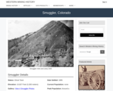
Smuggler, CO Mining Town. Western Mining History presents a brief summary of …
Smuggler, CO Mining Town. Western Mining History presents a brief summary of Colorado's Historical Mining Towns with links to additional Colorado resources for a mining town database and mines by county. Western Mining History is an historical site that provides information on mining, mining towns, the gold and silver rush, and Photos and maps of the western United States. This is a strong primary source resource that can be used for a variety of class research projects. Consider becoming a member or making a donation to help further the work of the site.
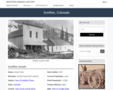
Sneffels, CO Mining Town. Western Mining History presents a brief summary of …
Sneffels, CO Mining Town. Western Mining History presents a brief summary of Colorado's Historical Mining Towns with links to additional Colorado resources for a mining town database and mines by county. Western Mining History is an historical site that provides information on mining, mining towns, the gold and silver rush, and Photos and maps of the western United States. This is a strong primary source resource that can be used for a variety of class research projects. Consider becoming a member or making a donation to help further the work of the site.
In this activity, students have to select the most convenient backcountry ski …
In this activity, students have to select the most convenient backcountry ski route to climb a peak located near Brighton ski resort (Utah). In order to select the route, they have to evaluate the information provided by the Utah Avalanche Center and to calculate distances and slope angles from a topographic map of the area.
Soil Carbon STEM Kit. The Natural Sciences Education & Outreach Center collaborates …
Soil Carbon STEM Kit. The Natural Sciences Education & Outreach Center collaborates with CSU faculty, National Parks and citizen science programs to translate their current scientific research into unique STEM experiences for students in the form of Educational Kits that can be checked out. Each kit contains just about all of the materials needed (minus common things like water and paper towels) to explore some really interesting scientific research topics.The kits are available for teachers and informal educators in Colorado to check out for a duration of a week by submitting either a local pickup form or a delivery form available at the linked website. https://www.youtube.com/watch?v=AVNHtSSSa8c This kit is provided free for educational use. This kit is available in Spanish also at the link provided. .
Students learn about one method used in environmental site assessments. They practice …
Students learn about one method used in environmental site assessments. They practice soil sampling by creating soil cores, studying soil profiles and characterizing soil profiles in borehole logs. They use their analysis to make predictions about what is going on in the soil and what it might mean to an engineer developing the area.
In this video, adapted from KUAC-TV and the Geophysical Institute at the …
In this video, adapted from KUAC-TV and the Geophysical Institute at the University of Alaska, Fairbanks, viewers learn how one-celled organisms in permafrost may be contributing to greenhouse gas levels and global warming.
Students collect a soil near their house or other location, analyze it …
Students collect a soil near their house or other location, analyze it using grain size, plot the locations and collectively create a soils map of campus or larger area. This exercise can be tailored for many different grade levels. I've used it from 4th grade through Physical Geology classes
This lesson will extend the learning on rocks with the Foss kit, …
This lesson will extend the learning on rocks with the Foss kit, Pebbles, Sand, and Silt to include soil. Students will perform the soil sifting activity like the one designed for rocks in the Foss it. Through their work, students will complete a Venn diagram of soil and rocks as a class.
Sonar technology allowed scientists to produce high-resolution maps of the sea floor …
Sonar technology allowed scientists to produce high-resolution maps of the sea floor for the first time. This sonar demonstration uses a Human Sound Wave to image the "sea floor" in a lecture hall. In doing so, students can see two-way travel times collected and plotted in real time. Students also evaluate sources of error that can be applied to a real sonar device.
(Note: this resource was added to OER Commons as part of a batch upload of over 2,200 records. If you notice an issue with the quality of the metadata, please let us know by using the 'report' button and we will flag it for consideration.)
During the first activity, students use materials to create an apparatus and …
During the first activity, students use materials to create an apparatus and process to investigate the ultimate destination for water delivered to a system. Students make quantitative measurements and compare two different soil substrates. The first activity results in a mental schema for how water ultimately flows through a system.
Students visit Drayton Hall historic plantation near Charleston, South Carolina and are …
Students visit Drayton Hall historic plantation near Charleston, South Carolina and are led on a field trip that starts with a discussion of documented historic changes that have affected the mansion and the surrounding property. The field trip continues with a study of Native American artifacts and ends with analysis of coastal plain deposits exposed along the Ashley River. Students use paleogeographic maps to discuss both historic and prehistoric changes to the landscape. Back in the classroom, students gather data to draw paleogeographic maps of their own school site through geologic time.
(Note: this resource was added to OER Commons as part of a batch upload of over 2,200 records. If you notice an issue with the quality of the metadata, please let us know by using the 'report' button and we will flag it for consideration.)
In this problem set, students are given space group symmetry diagrams for …
In this problem set, students are given space group symmetry diagrams for primitive (P) orthorhombic space groups. For each diagram they must write down the symmetry axis (either 2 or 21) that is parallel to each major axis, and give the symmetry plane (a, b, c, n, or m) that is normal (perpendicular)to each. They must also give the simplified Hermann-Mauguin symbol for the space group.
(Note: this resource was added to OER Commons as part of a batch upload of over 2,200 records. If you notice an issue with the quality of the metadata, please let us know by using the 'report' button and we will flag it for consideration.)
This site provides fun activities for children to do and make, while …
This site provides fun activities for children to do and make, while they learn about space and Earth science, and the technology that enables science. The Teachers Corner on the WWW site contains curriculum supplements originally published in the ITEA (International Technology Education Association) Technology Transfer Teacher magazine.
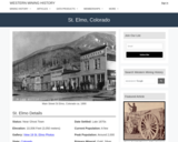
St Elmo, CO Mining Town. Western Mining History presents a brief summary …
St Elmo, CO Mining Town. Western Mining History presents a brief summary of Colorado's Historical Mining Towns with links to additional Colorado resources for a mining town database and mines by county. Western Mining History is an historical site that provides information on mining, mining towns, the gold and silver rush, and Photos and maps of the western United States. This is a strong primary source resource that can be used for a variety of class research projects. Consider becoming a member or making a donation to help further the work of the site.
Distribute a blank geologic-history timeline to pairs or small groups of students …
Distribute a blank geologic-history timeline to pairs or small groups of students at the start of an Earth History unit or course and ask them work together to fill it out as best they can.
(Note: this resource was added to OER Commons as part of a batch upload of over 2,200 records. If you notice an issue with the quality of the metadata, please let us know by using the 'report' button and we will flag it for consideration.)
In Stella, students act as astronomers, studying stars in a "patch" of …
In Stella, students act as astronomers, studying stars in a "patch" of sky in our own galaxy. Using simulated data from spectroscopy and other real-world instrumentation, students learn to determine star positions, radial velocity, proper motion, and ultimately, degree of parallax. As students establish their expertise in each area, they earn "badges" that allow them greater and easier access to the data.
This is a problem set that involves the calculation of velocities from …
This is a problem set that involves the calculation of velocities from a Reynolds number, determination of Stoke's Law applicability, and calculation of settling velocities for a variety of grain sizes and materials. This can be used in conjunction with a lab but is itself just a problem set.
This lab exercise provides a hypothetical, regional stratigraphic section for students to …
This lab exercise provides a hypothetical, regional stratigraphic section for students to interpret with regards to depositional environment and tectonic change through time. The assignment is designed to develop and evaluate student scientific writing skills by having students submit a 2-4 page (double-spaced) report detailing the stratigraphic history represented by the section. A primary focus is placed on identifying how and why sedimentary environments change through time and how this change integrates into a broader story of the geologic history for the region in which the section is preserved.
Understanding the relationship between the outcrop pattern and the 3-D geometry of …
Understanding the relationship between the outcrop pattern and the 3-D geometry of rock bodies is a challenge for students, especially those with low spatial ability. While memorization of learning aids, such as the "rule of V's" can help students interpret structure, it doesn't really help them understand the interaction between topography and rock bodies, and thereby be freed of having to rely on memory aids.
Google Earth offers the ability to view topography in 3D, and in areas of good exposure, the interaction between topography and rock bodies can be clearly visualized by manipulating the viewer's perspective. Through this user interaction, a much clearer understanding of how outcrop patterns related to rock structure can be gained.
(Note: this resource was added to OER Commons as part of a batch upload of over 2,200 records. If you notice an issue with the quality of the metadata, please let us know by using the 'report' button and we will flag it for consideration.)
No restrictions on your remixing, redistributing, or making derivative works. Give credit to the author, as required.
Your remixing, redistributing, or making derivatives works comes with some restrictions, including how it is shared.
Your redistributing comes with some restrictions. Do not remix or make derivative works.
Most restrictive license type. Prohibits most uses, sharing, and any changes.
Copyrighted materials, available under Fair Use and the TEACH Act for US-based educators, or other custom arrangements. Go to the resource provider to see their individual restrictions.