In this assignment, students evaluate depositional and erosional landforms created by wind …
In this assignment, students evaluate depositional and erosional landforms created by wind processes. This exercise looks at sand dune and yardang features using satellite images and topographic maps in an online GIS.
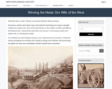
Western Mining History presents a short history of early metallurgy and Stamp …
Western Mining History presents a short history of early metallurgy and Stamp Mills used to extract gold, silver and other desired minerals from crushed ore. The resources shows Historical|Photographs of mining mills and other technology used to separate minerals from hard rock. Western Mining History is an historical site that provides databases, information on mining, mining towns, gold and Photos and maps of the western United States. Consider becoming a member or making a donation to help further the work of the site.
This site features World Wind 1.3, a NASA Learning Technologies application that …
This site features World Wind 1.3, a NASA Learning Technologies application that lets the user zoom from any satellite altitude into any place on Earth. It features 3D Engine, Blue Marble, Landsat 7, SRTM, Animated Earth, MODIS, GLOBE, Country & State Borders, Place Names, Visual Tools and Landmark Set. The user can download World Wind, reference an online manual, post to an online forum, view screen shot examples from various satellites, and read press coverage about World Wind.
This is a series of NASA Moderate Resolution Imaging Spectroradiometer (MODIS) satellite …
This is a series of NASA Moderate Resolution Imaging Spectroradiometer (MODIS) satellite images taken over a 10 year period, 2000-2010, showing the extent of deforestation in the State of Rondonia in western Brazil over that period of time.
Students will create their own glacier, and explore their effect on the …
Students will create their own glacier, and explore their effect on the land, modeling how they melt, how they move, and erode and deposit sediment. Students will be able to determine and describe isostatic rebound, create and identify common glacial landforms such as moraines, drumlins, erratics, kettle lakes, and striations, and explain the role glaciers play in landscape development and how climate change may impact glaciers and their related features.
Students demonstrate their skill in soils investigation and interpretation through independent projects …
Students demonstrate their skill in soils investigation and interpretation through independent projects undertaken in groups of one to three and presented in class using visual aids.
(Note: this resource was added to OER Commons as part of a batch upload of over 2,200 records. If you notice an issue with the quality of the metadata, please let us know by using the 'report' button and we will flag it for consideration.)
Introduction to the different types of slip behaviors that can occur on …
Introduction to the different types of slip behaviors that can occur on subduction thrust, and comparative analysis of data sets derived from earthquakes and slow slip events to learn to discriminate among events.
No restrictions on your remixing, redistributing, or making derivative works. Give credit to the author, as required.
Your remixing, redistributing, or making derivatives works comes with some restrictions, including how it is shared.
Your redistributing comes with some restrictions. Do not remix or make derivative works.
Most restrictive license type. Prohibits most uses, sharing, and any changes.
Copyrighted materials, available under Fair Use and the TEACH Act for US-based educators, or other custom arrangements. Go to the resource provider to see their individual restrictions.