This is a lab activity that is designed to help introductory, non-science …
This is a lab activity that is designed to help introductory, non-science majors integrate their geological knowledge near the end of the course. In this activity, students work in self-selected groups of up to four per group on the history of a sketch geological map.
Each student in the Geological Oceanography class writes a series of one-page …
Each student in the Geological Oceanography class writes a series of one-page papers for topics throughout the semester, presents one topic as a 3 to 5 minute oral presentation, and revises all papers as a portfolio for submission at the end of the semester. The eight topics are objects in the solar system, minerals, rocks, hydrothermal vents, volcanoes & earthquakes, marine sediments, hurricanes & typhoons, and tides.
This lab serves to introduce students to geologic time and serves as …
This lab serves to introduce students to geologic time and serves as an outline for the course through the semester.
Students use a tape register and must mark out the corresponding length of each Geologic Era and Eon towards the beginning of the course. Above Western time line Navajo students construct their own time line correlating events as best as possible. As the course progresses starting from 4.6bya each week they must draw major events that occur marking correct subdivisions of time and ages ago. As fossil life gets more complex such as beginning in the Paleozoic students are must take different categories of fossils or different periods so all are doing different things but working together. (Similarly the Navajo time line builds. This time line is taped around the room---and I would have liked to paint the two time lines along the corridor of the building but Maintenance axed it.
(Note: this resource was added to OER Commons as part of a batch upload of over 2,200 records. If you notice an issue with the quality of the metadata, please let us know by using the 'report' button and we will flag it for consideration.)
Students work in groups to develop content for am online hiking tour …
Students work in groups to develop content for am online hiking tour which is matched to the geologic time scale. This project has been used as a semester group work project in an introductory geologic history course, but could be adapted for high school or upper level and graduate courses focused on outreach.
When you ask the question What is geology? most people will initially …
When you ask the question What is geology? most people will initially respond that it is the study of rocks. This is true, but geology is also so much more than that. The truth is that geology is an intricate part of your everyday life.
This is a short writing assignment given in the second semester of …
This is a short writing assignment given in the second semester of an introductory geology course. Students are encouraged to come up with ideas for places around the world that they wish to investigate with respect to geology. The instructor cross-compares lists and assigns locations maximizing global spread of the places covered. Students must review not only the geological history of the location but how society in that place is influenced by the underlying landscape (e.g., mining for resources, natural hazards, etc). Goals include a) encouraging their curiosity about geology with respect to places that may have meaning to them, b) strengthening research and writing skills, and c) using this assignment as a way to synthesize concepts learned in class as related to a particular location around the world.
Short Description: This is an inquiry based field investigation where students gather …
Short Description: This is an inquiry based field investigation where students gather data on the Credit River from the rocks in the river bed, water speed, and maps. Students interpret their findings and develop new questions.
In this culminating activity, students will be assessed on what they have …
In this culminating activity, students will be assessed on what they have learned during the Geology unit of their Earth Science class. After conducting classroom and field studies on geology students will utilize this knowledge to interpret the rock layers and formation of the Grand Canyon. Outside of class students will read/review a website and complete a study guide to be reviewed by the teacher to assess students' learning. Following teacher review of study guides, the next class period(s) will be a discussion and questioning session(s) on the formation of the Grand Canyon.
Students choose a place that is named based on its relationship to …
Students choose a place that is named based on its relationship to geomorphology. They research and describe the geologic template, geologic processes and time involved in the formation of their chosen place and use Google Earth to report their results.
This two-week long laboratory exercise examines the linkages between the endogenic (tectonic …
This two-week long laboratory exercise examines the linkages between the endogenic (tectonic and isostatic) and exogenic processes that created the Eastern Snake River Plain (ESRP) landscape. The landform analysis portion of the exercise focuses upon recent basaltic volcanism and the Menan Buttes, the St. Anthony dunes and the fluvial drainage patterns that developed in the region.
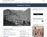
Georgetown, CO Mining Town. Western Mining History presents a brief summary of …
Georgetown, CO Mining Town. Western Mining History presents a brief summary of Colorado's Historical Mining Towns with links to additional Colorado resources for a mining town database and mines by county. Western Mining History is an historical site that provides information on mining, mining towns, the gold and silver rush, and Photos and maps of the western United States. This is a strong primary source resource that can be used for a variety of class research projects. Consider becoming a member or making a donation to help further the work of the site.
GetWET Water Education (Special Training Required for teachers prior to use, read …
GetWET Water Education (Special Training Required for teachers prior to use, read about the requirements on the linked page). The Natural Sciences Education & Outreach Center collaborates with CSU faculty, National Parks and citizen science programs to translate their current scientific research into unique STEM experiences for students in the form of Educational Kits that can be checked out. Each kit contains just about all of the materials needed (minus common things like water and paper towels) to explore some really interesting scientific research topics.The kits are available for teachers and informal educators in Colorado to check out for a duration of a week by submitting either a local pickup form or a delivery form available at the linked website. This kit is provided free for educational use. This Kit is available in Spanish.
Spreadsheets Across the Curriculum module/Geology of National Parks course. Students use foundational …
Spreadsheets Across the Curriculum module/Geology of National Parks course. Students use foundational math to calculate such earthquake-related numbers as fault displacement rate and earthquake recurrence interval associated with the San Andreas Fault at Point Reyes National Seashore.
The GigaPan Virtual Field Trip is used as a pre and post …
The GigaPan Virtual Field Trip is used as a pre and post assessment of student understanding of basic physical geology concepts and processes. Students are directed to a GigaPan image of Peyto Lake, Banff National Park, Alberta, Canada and asked to list observations and provide interpretations based on their observations.
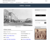
Gillette, CO Mining Town. Western Mining History presents a brief summary of …
Gillette, CO Mining Town. Western Mining History presents a brief summary of Colorado's Historical Mining Towns with links to additional Colorado resources for a mining town database and mines by county. Western Mining History is an historical site that provides information on mining, mining towns, the gold and silver rush, and Photos and maps of the western United States. This is a strong primary source resource that can be used for a variety of class research projects. Consider becoming a member or making a donation to help further the work of the site.
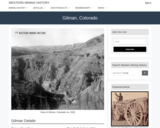
Gilman, CO Mining Town. Western Mining History presents a brief summary of …
Gilman, CO Mining Town. Western Mining History presents a brief summary of Colorado's Historical Mining Towns with links to additional Colorado resources for a mining town database and mines by county. Western Mining History is an historical site that provides information on mining, mining towns, the gold and silver rush, and Photos and maps of the western United States. This is a strong primary source resource that can be used for a variety of class research projects. Consider becoming a member or making a donation to help further the work of the site.
This Western Mining History database uses Mineral Resources Data System to list …
This Western Mining History database uses Mineral Resources Data System to list known Colorado historical mines by county. Each county site has links to the known mines within its borders. Some are known and named, others are unnamed. Mines should be assumed to be on private property unless other research is conducted. Data provided for each mine site include: Name, State, County, Elevation, Primary Mineral Mined, Latitude and Longitude and a link to Google Maps. Photos are provided where available. Additional information for some Mines are satellite photos, and ownership, business and historical records. Mining History is an historical site that provides information on mining, mining towns, the gold and silver rush, and Photos and maps of the western United States. This is a great database for student historical research or data and statistics classes. Consider becoming a member or making a donation to help further the work of the site.
The goal of this assignment is for students to recognize that adding …
The goal of this assignment is for students to recognize that adding some randomization and "noise" to a model yields different results each time we run the model, and we can pull some useful statistics from these model results. This introduces the concept of a Monte Carlo method to the students.
Using a glacier proxy, students design an experiment to connect glacial erosion …
Using a glacier proxy, students design an experiment to connect glacial erosion with glacial flow. Students choose from a variety of materials, determined what question they want their experiment or experiments to answer, design the procedure, test the experiment, and write up a lab report on the experiment.
No restrictions on your remixing, redistributing, or making derivative works. Give credit to the author, as required.
Your remixing, redistributing, or making derivatives works comes with some restrictions, including how it is shared.
Your redistributing comes with some restrictions. Do not remix or make derivative works.
Most restrictive license type. Prohibits most uses, sharing, and any changes.
Copyrighted materials, available under Fair Use and the TEACH Act for US-based educators, or other custom arrangements. Go to the resource provider to see their individual restrictions.