A learning activity for the "Do You Know That Clouds Have Names?" …
A learning activity for the "Do You Know That Clouds Have Names?" book in the Elementary GLOBE series. Students will explore the difference between the three types of contrails, make observations of contrails outside, and record their observations. Fifteen minutes later they will make follow-up observations to see how the contrails they observed have changed. The purpose of the activity is to help students identify contrails and learn to distinguish between the three types of contrails and to understand that contrails are human-made and some contrails become clouds in the sky. Students will be able to (1) identify the three types of contrails; (2) understand that contrails are created by jet airplanes; and (3) understand that some contrails become clouds.
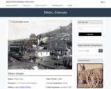
Elkton, CO Mining Town. Western Mining History presents a brief summary of …
Elkton, CO Mining Town. Western Mining History presents a brief summary of Colorado's Historical Mining Towns with links to additional Colorado resources for a mining town database and mines by county. Western Mining History is an historical site that provides information on mining, mining towns, the gold and silver rush, and Photos and maps of the western United States. This is a strong primary source resource that can be used for a variety of class research projects. Consider becoming a member or making a donation to help further the work of the site.
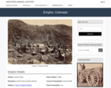
Empire, CO Mining Town. Western Mining History presents a brief summary of …
Empire, CO Mining Town. Western Mining History presents a brief summary of Colorado's Historical Mining Towns with links to additional Colorado resources for a mining town database and mines by county. Western Mining History is an historical site that provides information on mining, mining towns, the gold and silver rush, and Photos and maps of the western United States. This is a strong primary source resource that can be used for a variety of class research projects. Consider becoming a member or making a donation to help further the work of the site.
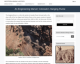
Western Mining History presents a history of the hanging flume built over …
Western Mining History presents a history of the hanging flume built over the San Miguel and Dolores Rivers in Western Colorado. The flume was meant to bring water to mining venture at great cost. It was built into the sheer cliff face.The resources shows Photos of miner's cabins and living conditions. Western Mining History is an historical site that provides databases, information on mining, mining towns, gold and Photos and maps of the western United States. Consider becoming a member or making a donation to help further the work of the site.
This is a lengthy glossary of highly technical terms focused on finance. …
This is a lengthy glossary of highly technical terms focused on finance. Its contents include words dealing with taxes, inheritance, interest rates, retirement plans, and every other aspect of personal finance, as well as many generic legal terms that are also used in the finance world.
Increasingly volatile climate and weather; vulnerable drinking water supplies; shrinking wildlife habitats; …
Increasingly volatile climate and weather; vulnerable drinking water supplies; shrinking wildlife habitats; widespread deforestation due to energy and food production. These are examples of environmental challenges that are of critical importance in our world, both in far away places and close to home, and are particularly well suited to inquiry using geographic information systems. In GEOG 487 you will explore topics like these and learn about data and spatial analysis techniques commonly employed in environmental applications. After taking this course you will be equipped with relevant analytical approaches and tools that you can readily apply to your own environmental contexts.
This is a service-learning project for students in Geography 204 (Weather, Climate …
This is a service-learning project for students in Geography 204 (Weather, Climate and Ecosystems). Students will assess prior estimates of carbon offsets associated with plant and soil biomass on their college campus; and as a result, they will understand the complexity of measuring the complex sources of carbon emissions and offsets; address the challenges of coordinating data collection and field measurement; and realize importance of estimation in public policy contexts.
(Note: this resource was added to OER Commons as part of a batch upload of over 2,200 records. If you notice an issue with the quality of the metadata, please let us know by using the 'report' button and we will flag it for consideration.)
Students make measurements of dam dimensions and water levels above and below …
Students make measurements of dam dimensions and water levels above and below a small, accessible earthen dam. They assess the soil texture in the field. They follow up by developing a simple flow net and estimating seepage rate as part of a problem set. They discuss their assumptions and the likely sources and magnitude of error.
(Note: this resource was added to OER Commons as part of a batch upload of over 2,200 records. If you notice an issue with the quality of the metadata, please let us know by using the 'report' button and we will flag it for consideration.)
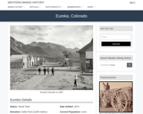
Eureka, CO Mining Town. Western Mining History presents a brief summary of …
Eureka, CO Mining Town. Western Mining History presents a brief summary of Colorado's Historical Mining Towns with links to additional Colorado resources for a mining town database and mines by county. Western Mining History is an historical site that provides information on mining, mining towns, the gold and silver rush, and Photos and maps of the western United States. This is a strong primary source resource that can be used for a variety of class research projects. Consider becoming a member or making a donation to help further the work of the site.
Crea un reloj de sol humano para medir el tiempo usando sombras. …
Crea un reloj de sol humano para medir el tiempo usando sombras. Actividad de Bolsa de STEM Semanal. Agentes de Colorado Americorp en los condados de Araphahoe, Denver, Garfield, Larimer y Weld. Trabajo apoyado por la Corporación para el Servicio Nacional y Comunitario bajo el número de subvención 18AFHCO0010008 de Americorps. Las opiniones o puntos de vista expresados en esta lección pertenecen a los autores y no representan necesariamente la posición oficial o una posición respaldada por la Corporación o el programa Americorps.
Ice core data allow students to explore a number of patterns while …
Ice core data allow students to explore a number of patterns while learning that researchers need to gather and interpret evidence to understand Earth's past. Students will explore core data collected in Western Greenland that document a few decades of Earth's atmosphere. Students are challenged to identify patterns and then use those patterns and background information to answer a few key questions. The data include measurements of temperature, dust, and atmospheric gases. Downloadable files are provided for those who intend to run the activity in person. For those running the activity with an online or virtual class, a separate page includes all of the necessary information for students to complete the activity, including an interactive graph and background readings. Support videos are provided.
This assignment allows students to utilize real soil data/information presented online to …
This assignment allows students to utilize real soil data/information presented online to learn how the some of the physical properties of the soil influence the chemistry of the soil and health of the ecosystem.
(Note: this resource was added to OER Commons as part of a batch upload of over 2,200 records. If you notice an issue with the quality of the metadata, please let us know by using the 'report' button and we will flag it for consideration.)
An introduction to processes associated with continental rifting, and resulting fault geometries …
An introduction to processes associated with continental rifting, and resulting fault geometries and distributions, and lithospheric responses, using seismic data examples from the Gulf of California.
This laboratory exercise explores the topographic signature of fluvial and glacial landscapes …
This laboratory exercise explores the topographic signature of fluvial and glacial landscapes in different tectonic environments. Students develop a list of mountain ranges around the world to explore, then extract topographic data from 90-meter SRTM DEMs, and develop a series of hypsometric curves for each range. Each student works on a single range, but as a class we build up a database of 10-15 ranges around the world. The hypsometric curves are compared with each other and with published curves to look for signals of fluvial incision vs. glacial erosion in the landscapes.
This activity is designed as both an introduction to GIS and an …
This activity is designed as both an introduction to GIS and an exploration of topographic steady-state. Students analyze DEMs from Taiwan to extract topographic profiles across the range. They reconstruct a series of datasets presented in Stolar et al., (2007), showing the progression of the range to steady-state as a space-for-time substitution from south to north. Students are expected to relate their observations from the topography to theoretical concepts discussed in class including accretion and uplift, steady-state, and critical wedge theory.
An extension involves developing a simple numerical model in Excel of a mountain range as it progresses to topographic steady-state landscape, allowing students to investigate the rise of a mountain range to steady-state both from Taiwan data and from their numerical model.
students are engaged in reflecting on whether plate tectonics is a general …
students are engaged in reflecting on whether plate tectonics is a general theory of planetary organization and evolution. Students use topographic, magnetic, spectral, and other data from NASA and ESA missions to determine whether "Earth-style" plate tectonics is functional on planets and moons elsewhere in the solar system. Students are engaged in a data-rich environment from which they must formulate and test multiple hypotheses. Throughout the process, students are engaged in small groups to identify what they need to learn to answer their questions, what resources are available to them, how best to report their findings, and how they can assess the amount of learning that is taking place.
Fairplay, CO Mining Town. Western Mining History presents a brief summary of …
Fairplay, CO Mining Town. Western Mining History presents a brief summary of Colorado's Historical Mining Towns with links to additional Colorado resources for a mining town database and mines by county. Western Mining History is an historical site that provides information on mining, mining towns, the gold and silver rush, and Photos and maps of the western United States. This is a strong primary source resource that can be used for a variety of class research projects. Consider becoming a member or making a donation to help further the work of the site.
No restrictions on your remixing, redistributing, or making derivative works. Give credit to the author, as required.
Your remixing, redistributing, or making derivatives works comes with some restrictions, including how it is shared.
Your redistributing comes with some restrictions. Do not remix or make derivative works.
Most restrictive license type. Prohibits most uses, sharing, and any changes.
Copyrighted materials, available under Fair Use and the TEACH Act for US-based educators, or other custom arrangements. Go to the resource provider to see their individual restrictions.