Using actual earthquake data from the circum-Pacific region, students make predictions about …
Using actual earthquake data from the circum-Pacific region, students make predictions about where earthquakes should occur in the immediate future. Data are provided in the form of global earthquake locations over 30 year time spans from 1900��2015. Students form groups and use one map to predict where earthquakes should occur during the subsequent 30 year interval. Students then compare their predictions to actual earthquake locations.
Students learn about the types of seismic waves produced by earthquakes and …
Students learn about the types of seismic waves produced by earthquakes and how they move the Earth. The dangers of earthquakes are presented as well as the necessity for engineers to design structures for earthquake-prone areas that are able to withstand the forces of seismic waves. Students learn how engineers build shake tables that simulate the ground motions of the Earth caused by seismic waves in order to test the seismic performance of buildings.
Students learn about seismology by using a sample seismograph constructed out of …
Students learn about seismology by using a sample seismograph constructed out of common classroom materials. The seismograph creates a seismogram based on vibrations caused by moving a ruler. The students work in groups to represent an engineering firm that must analyze the seismograph for how it works and how to read the seismogram it creates.
The stage is set for this exercise with a class period introducing …
The stage is set for this exercise with a class period introducing semi-brittle deformation: What does it look like? How does it happen? Over what time/length scales does it occur? Distributing candy bars with nuts (brittle) and caramel (ductile) provides a tasty sense of semi-brittle deformation while chewing. The lab is done ideally in groups of 3-4 with each group responsible for performing experiments on one apparatus (distributed shear, localized shear, and pressure cell). Each experiment (described in the attached file) has setup, running, and cleanup phases. During the running phase, students in other groups are encouraged to view key moments in the experiment (e.g., propagation of fractures, modifying pore fluid pressure, seismic events). When the lab is completed, groups are scrambled so each group contains at least one student from each experiment. Students in newly formed groups collaborate to produce a lab report, containing abstract, introduction, methods, results, discussion, and conclusion sections.
(Note: this resource was added to OER Commons as part of a batch upload of over 2,200 records. If you notice an issue with the quality of the metadata, please let us know by using the 'report' button and we will flag it for consideration.)
Sequence-stratigraphic and mass-balance analysis of experimental stratigraphy. Students are charged with evaluating …
Sequence-stratigraphic and mass-balance analysis of experimental stratigraphy. Students are charged with evaluating how basin subsidence geometry influences depositional patterns. In addition to providing practice applying sequence-stratigraphic methods, this project builds quantitative data-analysis and writing skills.
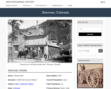
Sherman, CO Mining Town. Western Mining History presents a brief summary of …
Sherman, CO Mining Town. Western Mining History presents a brief summary of Colorado's Historical Mining Towns with links to additional Colorado resources for a mining town database and mines by county. Western Mining History is an historical site that provides information on mining, mining towns, the gold and silver rush, and Photos and maps of the western United States. This is a strong primary source resource that can be used for a variety of class research projects. Consider becoming a member or making a donation to help further the work of the site.
Spreadsheets Across the Curriculum module/Geology of National Parks course. Students use weighted …
Spreadsheets Across the Curriculum module/Geology of National Parks course. Students use weighted averages and data from air photos from 1939 to 2005 to calculate the rate of retreat of the shoreline and the advance of the front of dunes along the shoreline.
When students consider the causes of shoreline erosion they often assume waves …
When students consider the causes of shoreline erosion they often assume waves are the controlling process. Although they are correct there are other variables to consider. This assignment uses the Coastal Vulnerability Index (CVI) developed by the USGS to evaluate multiple factors that affect shoreline stability. The two sites used in this example- Virginia and Maine, were deliberately chosen because the wave height, i.e. wave energy, is almost the same but the erosion rates are different. Maine is more stable (lower CVI) than Virginia (high CVI), but waves are not the reason the stability of these two shorelines differ. This forces students to consider other variables such as underlying geology and sea level rise.
This activity is designed to enhance student comprehension of mineralogy and its …
This activity is designed to enhance student comprehension of mineralogy and its applications by having students read scientific articles from the journal American Mineralogist, answer questions, and discuss the article in class.
(Note: this resource was added to OER Commons as part of a batch upload of over 2,200 records. If you notice an issue with the quality of the metadata, please let us know by using the 'report' button and we will flag it for consideration.)
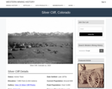
Silver Cliff, CO Mining Town. Western Mining History presents a brief summary …
Silver Cliff, CO Mining Town. Western Mining History presents a brief summary of Colorado's Historical Mining Towns with links to additional Colorado resources for a mining town database and mines by county. Western Mining History is an historical site that provides information on mining, mining towns, the gold and silver rush, and Photos and maps of the western United States. This is a strong primary source resource that can be used for a variety of class research projects. Consider becoming a member or making a donation to help further the work of the site.
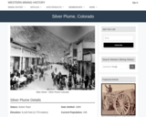
Silver Plume, CO Mining Town. Western Mining History presents a brief summary …
Silver Plume, CO Mining Town. Western Mining History presents a brief summary of Colorado's Historical Mining Towns with links to additional Colorado resources for a mining town database and mines by county. Western Mining History is an historical site that provides information on mining, mining towns, the gold and silver rush, and Photos and maps of the western United States. This is a strong primary source resource that can be used for a variety of class research projects. Consider becoming a member or making a donation to help further the work of the site.
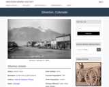
Silverton, CO Mining Town. Western Mining History presents a brief summary of …
Silverton, CO Mining Town. Western Mining History presents a brief summary of Colorado's Historical Mining Towns with links to additional Colorado resources for a mining town database and mines by county. Western Mining History is an historical site that provides information on mining, mining towns, the gold and silver rush, and Photos and maps of the western United States. This is a strong primary source resource that can be used for a variety of class research projects. Consider becoming a member or making a donation to help further the work of the site.
This is a short exercise that tests student's knowledge of interpreting eutectic …
This is a short exercise that tests student's knowledge of interpreting eutectic diagrams. The handout provides diagrams with questions to test students' comprehension of the diagrams.
(Note: this resource was added to OER Commons as part of a batch upload of over 2,200 records. If you notice an issue with the quality of the metadata, please let us know by using the 'report' button and we will flag it for consideration.)
This is a short exercise that tests student's knowledge of interpreting peritectic …
This is a short exercise that tests student's knowledge of interpreting peritectic diagrams. The handout provides a diagram with questions to test students' comprehension of the diagram.
(Note: this resource was added to OER Commons as part of a batch upload of over 2,200 records. If you notice an issue with the quality of the metadata, please let us know by using the 'report' button and we will flag it for consideration.)
Hands-on demonstrations of advection and diffusion of heat in subduction zones, and …
Hands-on demonstrations of advection and diffusion of heat in subduction zones, and their controls on slab thermal evolution and relationships to melting, using analog models.
Students identify and draw slices through cylinders and partial cylinders, and use …
Students identify and draw slices through cylinders and partial cylinders, and use gestures to visualize slicing planes. This practice with visualizing slices through idealized geometric shapes is preparation for visualizing slices through geological features.
Students examine images of brachiopods, mollusks, and coquinas. They identify, visualize, and …
Students examine images of brachiopods, mollusks, and coquinas. They identify, visualize, and sketch slices through a variety of shelly organisms, then apply what they've learned to identify fossils in several samples of coquina.
(Note: this resource was added to OER Commons as part of a batch upload of over 2,200 records. If you notice an issue with the quality of the metadata, please let us know by using the 'report' button and we will flag it for consideration.)
This unit uses the slinky seismometer as a means of studying physics …
This unit uses the slinky seismometer as a means of studying physics concepts such as waves, sound and the speed of sound vs speed of light, resonance, electricity and magnetism, Lenz Law and magnetic dampening (backwards engineering). Students experiment with the basic parts of the seismometer and either build or connect the seismometer to the internet to take and upload data.
No restrictions on your remixing, redistributing, or making derivative works. Give credit to the author, as required.
Your remixing, redistributing, or making derivatives works comes with some restrictions, including how it is shared.
Your redistributing comes with some restrictions. Do not remix or make derivative works.
Most restrictive license type. Prohibits most uses, sharing, and any changes.
Copyrighted materials, available under Fair Use and the TEACH Act for US-based educators, or other custom arrangements. Go to the resource provider to see their individual restrictions.