This Western Mining History database uses Mineral Resources Data System to list …
This Western Mining History database uses Mineral Resources Data System to list known Colorado historical mines by county. Each county site has links to the known mines within its borders. Some are known and named, others are unnamed. Mines should be assumed to be on private property unless other research is conducted. Data provided for each mine site include: Name, State, County, Elevation, Primary Mineral Mined, Latitude and Longitude and a link to Google Maps. Photos are provided where available. Additional information for some Mines are satellite photos, and ownership, business and historical records. Mining History is an historical site that provides information on mining, mining towns, the gold and silver rush, and Photos and maps of the western United States. This is a great database for student historical research or data and statistics classes. Consider becoming a member or making a donation to help further the work of the site.
Students are given the opportunity to learn a process-based approach to river …
Students are given the opportunity to learn a process-based approach to river research, by developing research questions about river form and function in Maine. Students filmed themselves while collecting and analyzing their data. The final product is a 6-minute video, created in Final Cut Pro X, that contained a description of their project,their hypotheses, analysis/results, and conclusions.
An attempt to help students better understand both the nature of river …
An attempt to help students better understand both the nature of river flow and its significance to human society, this lab follows the historic efforts of the Army Corps of Engineers to 'improve' the Mississippi River channel for commercial navigation. Students start by taking a section of the natural river channel and designing a river management program of wing dam and riprap construction that would manipulate the river's natural erosion and deposition processes to force the river itself to carve a deeper, more navigable channel. They then compare their plan to the one designed by the Corps and consider the implications of any significant differences between the two schemes. They are then asked to determine the environmental consequences of their proposed plan on the greater river system.
After this initial exploration, students compare the Corp's early efforts at wing dam and riprap management with its later plan of lock and dam construction and again investigate the impact of the two management schemes on the greater river system. The lab also considers differences in the cultural perspectives of 19th century Dakota and Euro-American communities regarding river systems. In concluding essays, the students must consider the environmental aspects of river management, specifically recognizing what was lost from the river system the Dakota originally knew.
(Note: this resource was added to OER Commons as part of a batch upload of over 2,200 records. If you notice an issue with the quality of the metadata, please let us know by using the 'report' button and we will flag it for consideration.)
Student materials for this exercise include a Microsoft Excel spreadsheet with peak …
Student materials for this exercise include a Microsoft Excel spreadsheet with peak discharge data for the Hillsborough River and Curiosity Creek, a .zip file containing two versions (PDF and JPG) of the topographic map of the Sulphur Springs quadrangle, and a simplified sketch map of the quadrangle. The exercise is divided into three parts. In Part I, students study the Sulphur Springs topographic quadrangle to gain a general idea of the landscape. The students identify drainage divides on the quadrangle and outline the drainage basins on the sketch map. Part II includes calculating the frequency and probability of various sized floods and creating a recurrence curve using Microsoft Excel charts. Students apply their knowledge to decide whether to buy a house on the floodplain of the Hillsborough River. In Part III, students use their results to interpret the potential for flooding along the main river and one of its tributaries. Students compare recurrence curves to deduce that having more years of data leads to a more reliable flood forecast. They search online to determine the reasons for particular floods and contrast the effects on the two streams.
(Note: this resource was added to OER Commons as part of a batch upload of over 2,200 records. If you notice an issue with the quality of the metadata, please let us know by using the 'report' button and we will flag it for consideration.)
This is the final lab for an Introductory Physical Geology class. Students …
This is the final lab for an Introductory Physical Geology class. Students apply a semester of learned geology skills toward evaluating house building sites near our campus. They encounter evidence of faulting, mass wasting, isostatic rebound, and ancient Alaskans as part of the exercise.
(Note: this resource was added to OER Commons as part of a batch upload of over 2,200 records. If you notice an issue with the quality of the metadata, please let us know by using the 'report' button and we will flag it for consideration.)
The Original Coloradans Social Studies Lesson 4 designed to be used with …
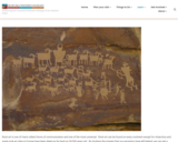
The Original Coloradans Social Studies Lesson 4 designed to be used with The Original Coloradans Artifact Kit. Lessons 1, 2 and 4 can be completed without the artifacts from the kit. These kits are available through Musuems of Western Colorado to D51 Teachers. This lesson can be adapted to use without the kit. Students will create their own "rock art" using red tempera paint on brown or tan construction paper. Students will be able to: • distinguish petroglyphs from pictographs, • create their own “rock art” and evaluate each other’s symbols, • theorize on the importance of rock art to ancient people, • describe how rock art vandalism has a negative impact on our understanding of history. For more background information, see Rock Art and Cultures of the Colorado Plateau https://museumofwesternco.com/rock-art/
Through five lessons, students are introduced to all facets of the rock …
Through five lessons, students are introduced to all facets of the rock cycle. Topics include rock and mineral types, material stresses and weathering, geologic time and fossil formation, the Earth's crust and tectonic plates, and soil formation and composition. Lessons are presented in the context of the related impact on humans in the form of roadway and tunnel design and construction, natural disasters, environmental site assessment for building structures, and measurement instrumentation and tools. Hands-on activities include experiencing tensional, compressional and shear material stress by using only hand force to break bars of soap; preparing Jeopardy-type trivia questions/answers for a class game that reinforces students' understanding of rocks and the rock cycle; creating "fossils" using melted chocolate; working within design constraints to design and build a model tunnel through a clay mountain; and soil sampling by creating tools, obtaining soil cores, documenting a soil profile log, and analyzing the findings to make engineering predictions.
Students reinforce their understanding of rocks, the rock cycle, and geotechnical engineering …
Students reinforce their understanding of rocks, the rock cycle, and geotechnical engineering by playing a trivia game. They work in groups to prepare Jeopardy-type trivia questions (answers) and compete against each other to demonstrate their knowledge of rocks and engineering.
Rocks cover the earth's surface, including what is below or near human-made …
Rocks cover the earth's surface, including what is below or near human-made structures. With rocks everywhere, breaking rocks can be hazardous and potentially disastrous to people. Students are introduced to three types of material stress related to rocks: compressional, torsional and shear. They learn about rock types (sedimentary, igneous and metamorphic), and about the occurrence of stresses and weathering in nature, including physical, chemical and biological weathering.
This lab helps students bring together their ability to describe and identify …
This lab helps students bring together their ability to describe and identify rocks and to push students to think about how the rocks formed based upon their understanding of the geological processes taking place at certain tectonic boundaries.
(Note: this resource was added to OER Commons as part of a batch upload of over 2,200 records. If you notice an issue with the quality of the metadata, please let us know by using the 'report' button and we will flag it for consideration.)
This lab helps students link concepts about how rocks form with observations …
This lab helps students link concepts about how rocks form with observations about how rocks look. It is designed to help them learn rock classification in a more connected manner than is usual.
This is a guided inquiry field investigation in an urban setting. This …
This is a guided inquiry field investigation in an urban setting. This investigation focuses on making observations, recording information, asking questions, and identifying the types of rocks used on buildings in downtown St. Paul, MN.
In this earth science unit, the students will observe rocks from the …
In this earth science unit, the students will observe rocks from the FOSS Pebbles, Sand & Silt kit as well as their own personal rocks. They will use scientific tools to aid in their observations, then form investigatory questions for their own inquiry.
Students test rocks to identify their physical properties (such as luster, hardness, …
Students test rocks to identify their physical properties (such as luster, hardness, color, etc.) and classify them as igneous, metamorphic or sedimentary. They complete a worksheet table to record all of the rock properties, and then answer worksheet questions to deepen their understanding of rock properties and relate them to the cavern design problem.
Students will use visual analysis to examine two images of rocks. They …
Students will use visual analysis to examine two images of rocks. They will make their own observations of individual rocks through drawing, and understand how the same observation skills can be used in the study of geology.
No restrictions on your remixing, redistributing, or making derivative works. Give credit to the author, as required.
Your remixing, redistributing, or making derivatives works comes with some restrictions, including how it is shared.
Your redistributing comes with some restrictions. Do not remix or make derivative works.
Most restrictive license type. Prohibits most uses, sharing, and any changes.
Copyrighted materials, available under Fair Use and the TEACH Act for US-based educators, or other custom arrangements. Go to the resource provider to see their individual restrictions.